


Original Wildfolio illustration of Mount Fuji above a lake and pine forest

YOUR OUTDOOR JOURNAL, ON IPHONE

Every walk.
A story to keep.

Record the route. Put it on your favorite photo.
Keep the places, stamps and little moments that make a journey yours.

Download on the App Store ↗Free · iPhone · iOS 17+
Version 1.1.0 is available now

Available in the US, Hong Kong and other regions.
Not currently available in mainland China. See availability ↓

Every walk is worth remembering.Mount Fuji · Original product illustration

Keep the view.
Remember the feeling.

241Destination stamps
10Interface languages
GPSYour route, recorded
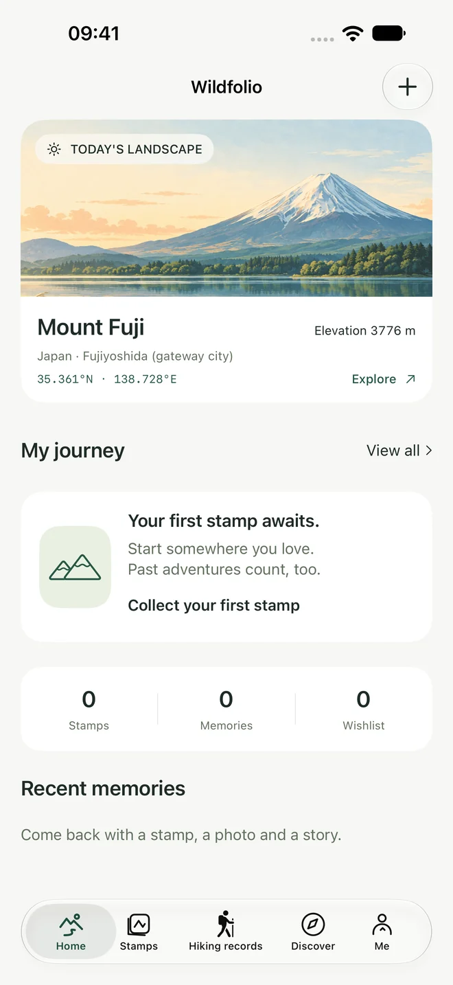
Wildfolio home screen showing the daily illustration, journey totals and demo memories

Native app screen · Demonstration records

01 / YOUR FIELD JOURNAL

A small place for
a wider world.

A long mountain day or an afternoon by a lake. Both deserve a page.

01

Remember a visit

Choose a destination, add the date and leave yourself a note. Photos and routes are optional. Remember only the month or year? Keep the date that way.

02

Watch a journey take shape

Revisit trip counts, time and distance. Find old outings by year, activity or place. Returning to a favorite mountain can mean another entry.

03

Leave room for the next trip

Save a wishlist, explore 241 destinations across 40 countries, and collect stamps from your own visits. A daily illustration offers another little window outside.

02 / EVERY STEP COUNTS

From the first step
to the way back.

Open the map, choose hiking, climbing or trail running, and start recording.

01

Record with your screen locked

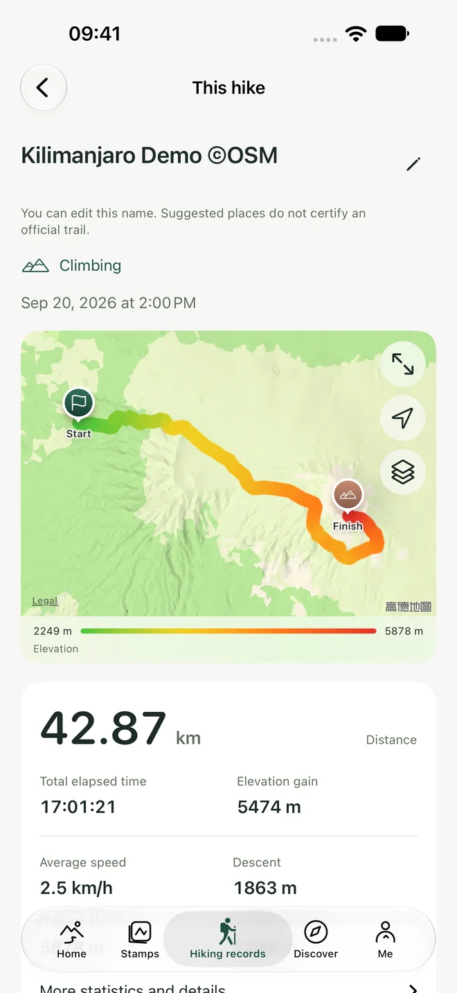
Keep your route, distance, elapsed time, speed or pace, and available elevation, ascent and descent. Pausing stops location collection while total time keeps running.

02

See the ups and downs

Reliable elevation colors the route. Missing sections stay disconnected. Pause, then hold for three seconds to finish and save a report.

03

Bring a terrain reference

Download a selected area in advance for offline elevation terrain. It does not include roads, place names, satellite images or navigation. Online map styles need a connection.

GPS recording does not require continuous internet. Location quality depends on your surroundings; distance and elevation are estimates.

Kilimanjaro demonstration report with an elevation-colored route, distance, time and ascent

Native app screen · Demonstration route
© OpenStreetMap contributors
Simulated timing and terrain-derived elevation, not an actual hike.

03 / YOUR PHOTO, YOUR WAY

Keep the view.
Add the way there.

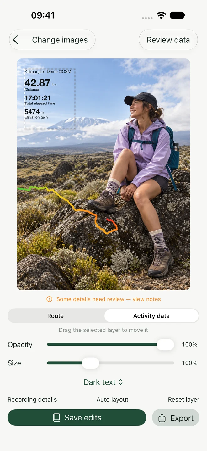
Put a route and activity data on your own photo. Move each layer until the landscape has room to breathe.

  1. 1

    Choose your photo and route

    Use a completed Wildfolio hike, a route screenshot or a GPX file.

  2. 2

    Review, then make it yours

    Check imported data and route details. Move, resize and change the opacity of the route and data layers independently; choose a text color.

  3. 3

    Save the edit and the memory

    Export to Photos or the system share sheet. Save editable compositions to return to later. A hike stays saved even if you make no photo.

Follow the photo guide ↗
Wildfolio photo editor with separate route and activity data layers, size and opacity controls

Native app screen · AI-generated demonstration photo
Public route and simulated timing; not a real activity.

NOTES FROM THE FIELD

A little help
keeping the memories.

Practical guides for making trail photos and a journal you will want to come back to.

PERSONAL BY NATURE

Your story.
Your choice to share.

Photo composition and text recognition run on your iPhone. Records are saved locally by default. No separate password account, ads or third-party analytics SDKs.

Enable optional iCloud sync for completed trips, journal entries, your wishlist and saved layouts. It needs an internet connection and available iCloud storage. Private notes are not automatically included in exported pictures.

Read the privacy policy ↗

TAKE WILDFOLIO WITH YOU

Ready for your
next little adventure.

Free · iPhone · iOS 17 or later
Ten interface languages

AVAILABLE NOW 1.1.0

Record, create, remember.

GPS hiking records, route photos, destination stamps and a private journal, with optional iCloud sync.

Availability follows your Apple Account storefront. Wildfolio is not currently available in mainland China.

AWAITING APPLE REVIEW 1.1.1

A fresh look in the store.

Submitted on October 1, 2026, with new store screenshots and presentation. App features are unchanged from version 1.1.0.

Checked October 1, 2026. Your App Store listing is the final source for the available version.

BEFORE YOU SET OFF

A few things
to know.

Do I need a GPS track to keep a journal?

No. Add a destination visit, date and optional notes. Photos and a GPS recording are not required, and you can record past trips.

Does Wildfolio provide trail navigation?

No. It records your own outing and helps you remember it. Offline terrain is an elevation reference, not a road or trail map. Destination descriptions do not establish current conditions.

Will my journal sync to another iPhone?

Optional iCloud sync can transfer completed trips, journal entries, your wishlist and saved photo layouts using the same Apple Account. Enable it yourself and keep enough iCloud space available. Export important pictures separately.

Which languages are supported?

Simplified and Traditional Chinese, English, Japanese, Korean, Spanish, French, Russian, Portuguese and Arabic. Personal titles, notes and original stamp inscriptions retain their original text.

How can I get help?

Visit Help & support, or open Me → Problem feedback in the app to compose an email. You review and send the message yourself.